What is a Cross-Section ?
A cross section views the earth as if it were cut open and viewed from the side, similar to cutting a cake and seeing the various layers inside. A cross section helps to understand the three dimensional geometry of the rock layers. Cross sections show thicknesses, dip directions, folds, faults, unconformities, sediment thickness changes, igneous intrusions and etc.
Cross sections are interpretive in nature, as they use data from specific sites to interpret what the geological characteristics would be for areas that do not have specific data. The scarcer the subsurface data, the larger the interpretative factor will be. A cross section is constructed by using surface geological maps, geophysical logs, and core samples.
Below are a number of cross-sections illustrating many of the aquifers within Plum Creek Conservation District.
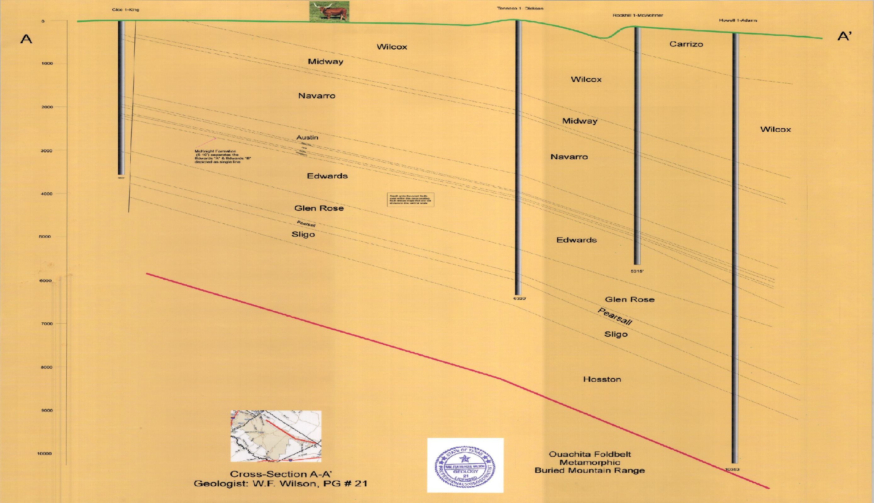
Cross Section AA Big
Cross Section AA: Looks at the geological subsurface profile of eastern
portions of the District that extend from Northeast Caldwell County
approximately 40 miles down to southeastern portions of Caldwell County. The cross
section was compiled using 4 geophysical logs. The cross-section includes the geologic
formation of the Edwards, Wilcox, Midway, Navarro and Trinity formations down to the
Ouachita Fold Belt.
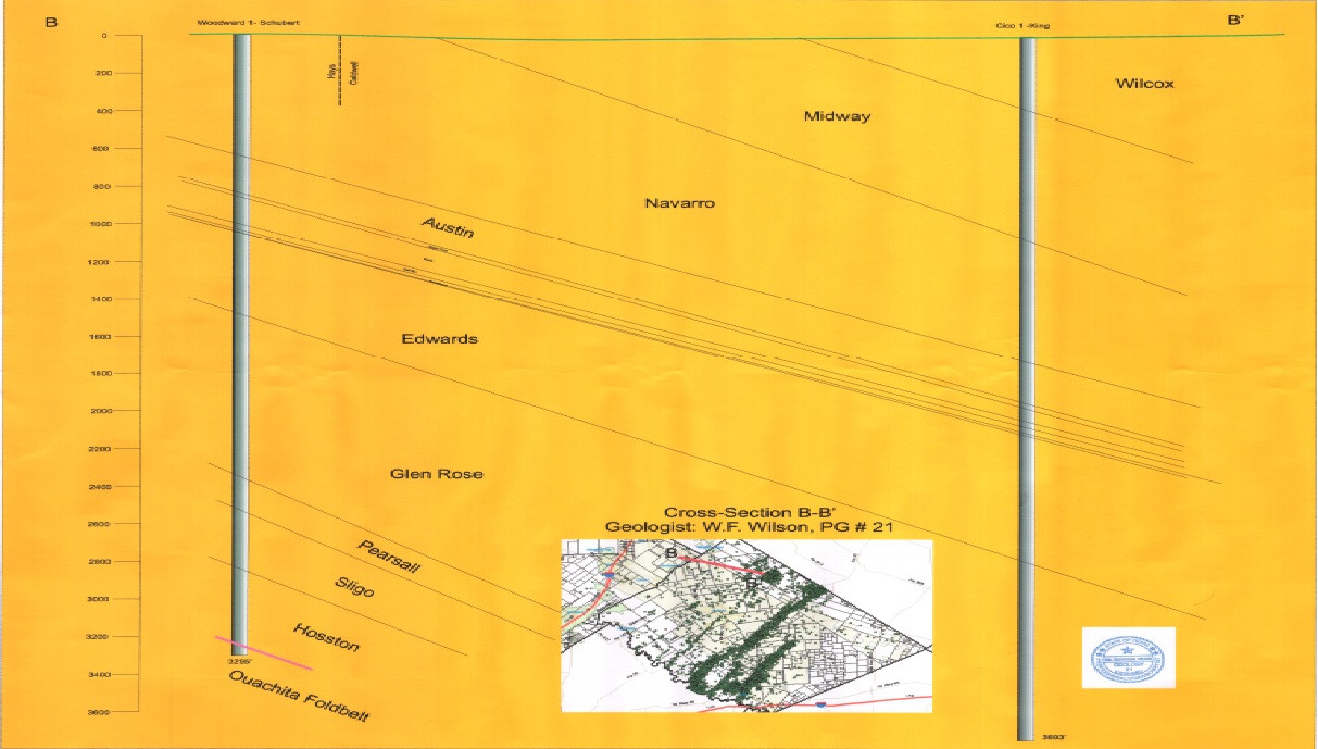
Cross Section BB
Cross Section BB: Looks at the geological subsurface profile of areas in Southeastern Hays County and Northeastern Caldwell County. The cross section uses two geophysical logs. The cross-section includes the geologic formations of the Edwards, Wilcox, Midway, Navarro and Trinity formations down to the Ouachita Fold Belt.
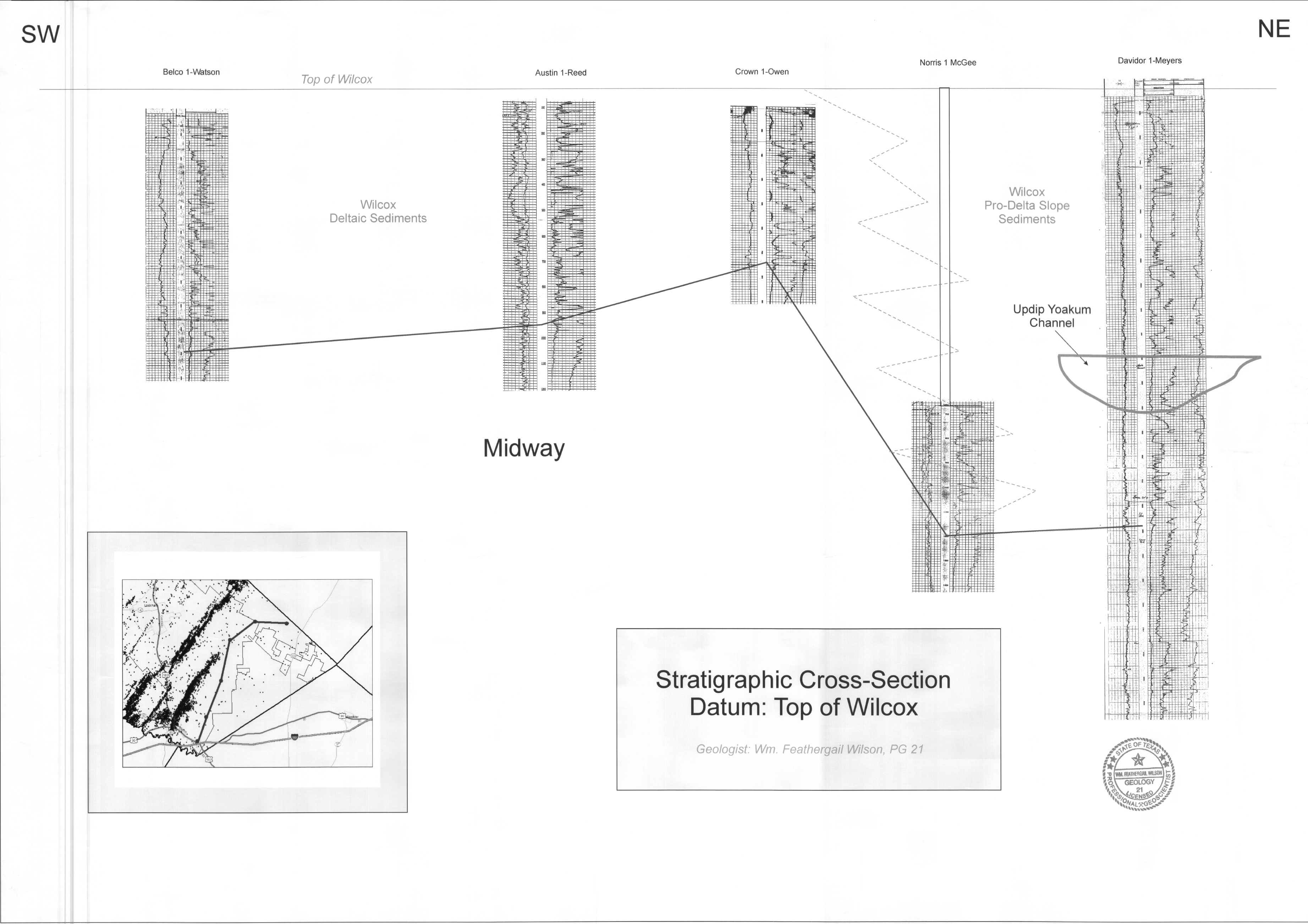
Top of Wilcox Cross Section
Cross Section –Top of Wilcox: Looks specifically at the top of the Wilcox formations. The cross section extends from areas near the City of Luling north-easterly across Caldwell County approximately 20 miles. The cross section uses 5 geophysical logs. This cross section also depicts the Joachim Channel.
CW-1 Cross Section
CW-1 Cross Section: Looks at the geological subsurface profile of central Caldwell County beginning at the Hays/Caldwell County line and extending southeasterly towards Luling approximately 25 miles. The cross section uses eight geophysical logs. The cross-section includes the geologic formations of the Wilcox, Midway, Navarro and Leona along with the location of a fault.
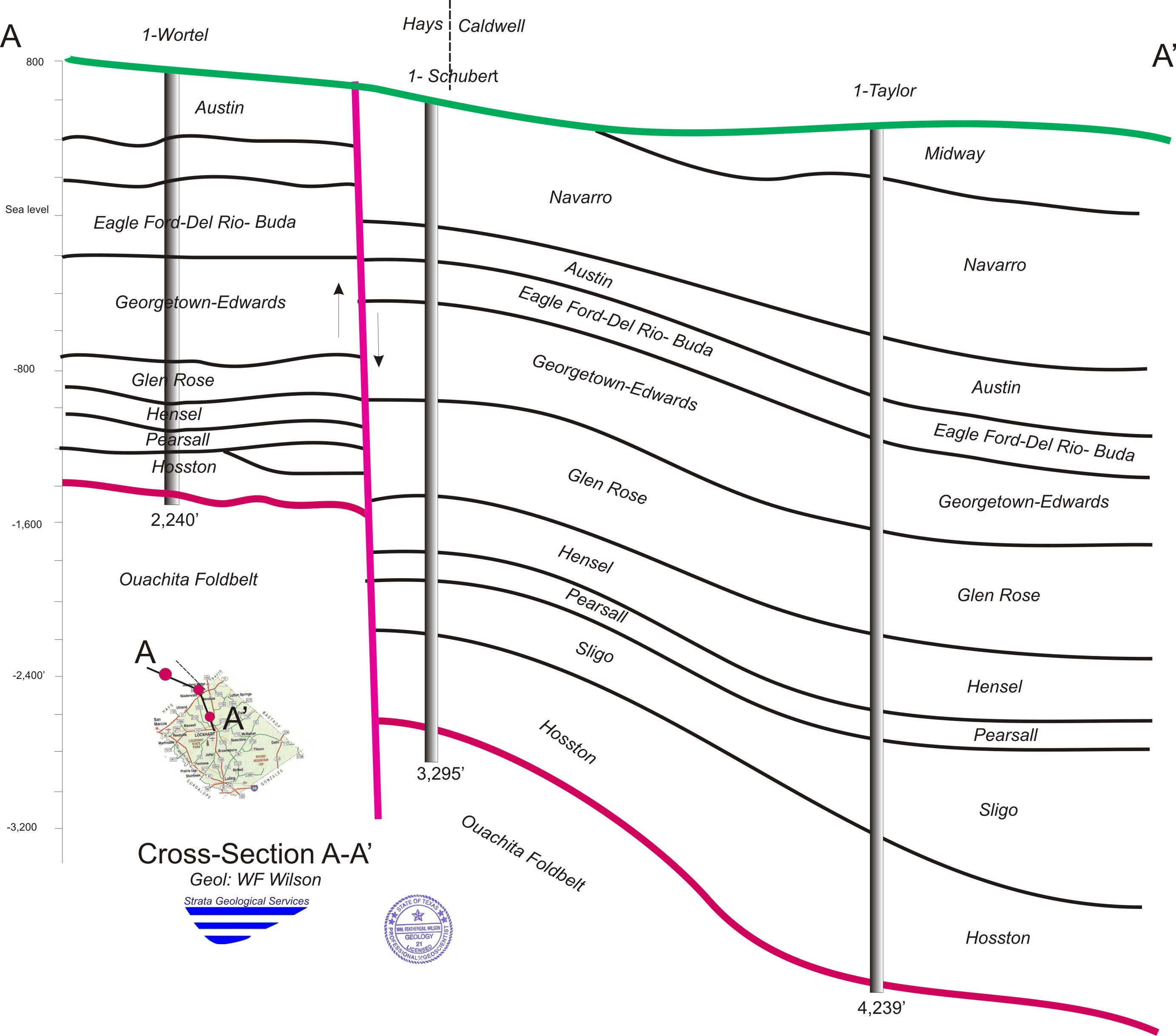
Hays Cross Section
Hays Cross Section: Looks at the geological subsurface profile in the area of south central Hays County and extending into north central Caldwell County. The cross section uses three geophysical logs. The cross-section includes the geologic formations of the Edwards, Austin Chalk, Midway, Navarro and Trinity formations down to the Ouachita Fold Belt.
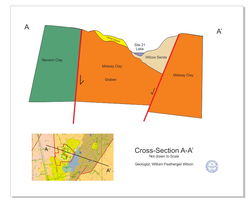
Site 21 Cross Section
Site 21 Cross Section: Looks at the geological subsurface profile in the area of site # 21, Northeast of Lockhart approximately 5 miles. The cross-section includes the geologic formations of the Leona, Midway, and Navarro.

Cross Section LK
LK Cross Section: Looks at the geological subsurface profile for areas in north central Caldwell County extending down to south central Caldwell County approximately 37 miles. The cross section uses six geophysical logs The cross-section includes the geologic formations Edwards, Austin Chalk, Midway, Navarro and Trinity formations down to the Hosston.
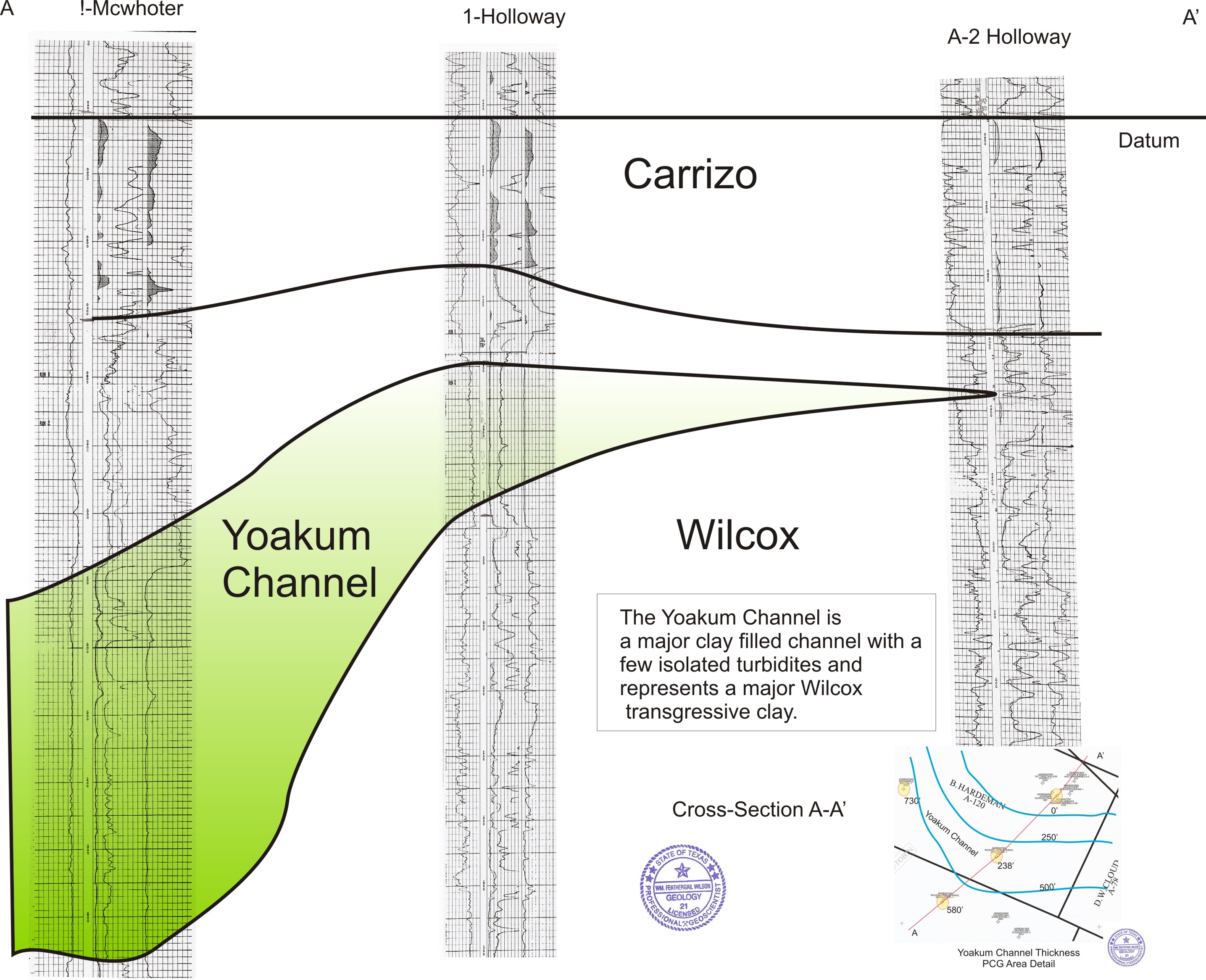
Yoakum Cross-Section
Yoakum Channel Cross Section: Looks at the geological subsurface profile for areas in southeastern Caldwell County. The cross section uses three geophysical logs The cross-section includes the geologic formations of the Wilcox, Carrizo, and Yoakum Channel.